November 5, 2018
This article focuses on a modern method of creating impressive three-dimensional visualizations in a short space of time without having to make complicated models.
You must have come across this: the visualization of any process looks as good as its author is skillful and proficient in graphic design. Many years ago, visualizations were done in a simplistic, flat, and plain style. Later, however, the advent of more powerful computers and higher-quality graphics software corresponded to the higher-quality visualizations created with SCADA systems. Realistic models of tanks, pipes, machines, and devices made with three-dimensional modeling tools began to be used in diagrams. The resulting visualization then became more attractive and was thus closer to real technological equipment.
After that, to make the perfect visualization, some companies started modeling complete production lines and halls using 3D tools. Within the visualization, the model could be zoomed in, zoomed out, and rotated in any direction. The resulting application had the advantage of being almost perfectly authentic. This method of visualization does have its disadvantages, though. Any three-dimensional modeling is time-consuming and financially demanding. It must be performed – using special software – by an expert down to the last detail. If significant technological changes occur in the future, everything must be remodeled. Today's state-of-the-art graphics tools, however, allow doing it in a much faster and easier way.
GEOVAP is – in the Czech Republic – an exclusive representative of the German company NavVis GmbH, which is a developer and manufacturer of professional 3D indoor mapping solutions. This service is marketed under the trade name Indoor3D. NavVis M6 Indoor Mobile Mapping System is an indoor mobile mapping system equipped with six high-resolution cameras, four laser lidars, and other sensors. It allows you to capture up to 20,000 square meters of area per day. Data (point clouds, 360° imagery) is stored on an SSD and then processed automatically.
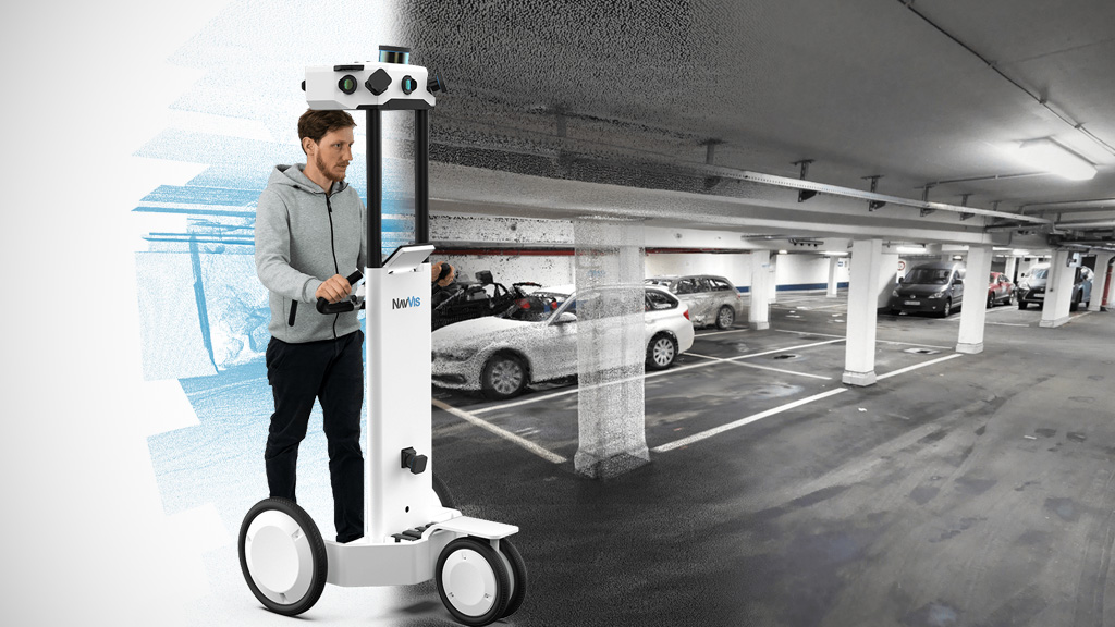
3D indoor scanning
3D indoor scanning
The result is a realistic 3D indoor model of a hallway or building capturing even the smallest details. You can walk through the interior in the same way as Google Street View is used. But this is not the end. It's the beginning! There are a large number of methods of use.
The so-called points of interest can be simply inserted in a three-dimensional model.
An IT technician's points of interest can be, for example, network sockets, printers, computers, and data projectors. Then, any information can be attached to each device. A person responsible for fire safety can have the following points of interest: hydrants, fire extinguishers, fire alarms, smoke detectors. Information attached to fire extinguishers can be, for example, their types, the next revision date, or a video that shows how to properly use a fire extinguisher of a given type. A person in charge of a company's property records will make, for example, furniture registration labels or machines as points of interest. Everyone can create their own points of interest of any type, manage them, and share them with other workers.
These points of interest can be displayed as icons on a map. To move within a point of interest, click on the icon it represents. A video, document, or website attached to a point of interest serve as a source of detailed information on the point. Thus, the 3D model allows creating any extensions used by various groups of workers (workflow management). After logging on to the system, you can display only those points of interest within the interior to which you have access and in which you're interested.
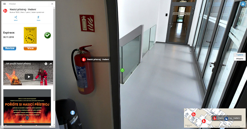
A point of interest (detail – fire extinguisher)
A point of interest (detail – fire extinguisher), NavVis
In a shopping mall, for example, the stores' points of interest are displayed to customers, thus allowing them to learn about special offers, opening hours, or to directly buy goods from a seller over the Internet. If, however, the shopping mall's energy manager is logged on to the system, commercial offers are no longer displayed. Instead, each store's consumption (electricity, water, heat) appears, including any other points of interest important to the manager.
What is important and what we want to emphasize is that points of interest can also be dynamic. Any sensors' live data can be attached to the 3D model. In this way, you can display current temperatures, pressures, flows, relative humidities, CO2 concentrations, valve positions, states of meters, pumps, and any other sensors, including IoT. All this data can be linked from the Reliance SCADA system, which then gives the 3D model another level of user possibilities. After clicking a sensor, a historical trend of its measured values is displayed.
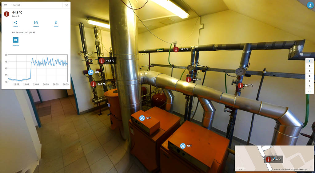
A 3D boiler room with live data
A 3D boiler room with live data
Three-dimensional indoor mapping is used by many major companies, such as BMW, Daimler (Mercedes-Benz), Siemens, Allianz, Deutsche Telekom, Deutsches Museum Munich či Munich Airport.
Indoor navigation is the icing on the cake. A mobile application available for Android and Apple has been designed for this purpose. The application allows simple navigation to any point of interest or to any room. It is suitable for use not only in large buildings like universities or civic buildings, but also in large complexes consisting of many individual buildings, such as manufacturing facilities. In these buildings, the system can navigate employees "from chair to chair"

Height and width scanning
Height and width scanning
Perhaps you wonder what to do when the layout of the interior changes significantly. In such a case, you can easily and quickly resurvey the interior. The updated 3D model then replaces the original data. The points of interest you had created earlier no longer need to be inserted again. They stay in place, so model updates can be very fast with no extra work.
GEOVAP also has equipment for 3D outdoor laser mapping. By combining the two mapping methods, complete 3D models of buildings, facilities, or even cities can be created. Such a 3D model can serve as the foundation for both complete ERP systems and smart city projects.

July 3, 2026
How to migrate from the
32-bit version of Reliance 4 or Reliance 5 to the 64-bit version of Reliance 5.
May 6, 2026
The 16th edition of the Reliance Success Story Awards competition is now underway.

If you have any questions, please feel free to email or call us.
Phone:
Info:
Sales:
Suppor:
Phone:
Info:
Sales:
Support:
Phone:
Info:
Sales:
Support:
GEOVAP
Cechovo nabrezi 1790
530 03 Pardubice
Czechia
© 2026 GEOVAP | Terms of Use and Privacy Policy | Cookie preferences | Write to us